Category Archives: Cycling

Great Vic, day six

Day five of riding (after the rest day) was from Traralgon to Yarragon. The route went north of the M1 to Melbourne, west along the La Trobe valley.

The slogan fire the Great Vic is Spend a week in another world. As is my wont, I’ve reflected on what kind of world this is.

It’s a world in which wearing lycra in public is perfectly normal, even in frightening shades of purple.

It’s a world of queues: food, shower, toilet, laundry, phone charging, …

It’s a world in which starting lunch at 10am is perfectly normal.

It’s a world whose background music is the sound of generators. They power pumps for loos, water points, showers, laundry/washing-up, as well as the larger infrastructure.

This world has distinct language: WARBYs, on your right, clear, slowing, etc. They all have clear meaning on the road or in the camp.

Odometer record.
Orbea: 22 469km.
Avanti: 3953.7km.
Giro: 3439km.

Today started off cool, with very limited visibility due to fog. This crafted some beautiful effects. For proof…
image

Passing through three major valleys saw a bit of climbing, though we never went higher than 220m above sea level.

I think the legs of the younger two felt a little tired after not riding yesterday. Not that they went slower, just that they felt the effects.

Once we reached lunch at Willow Grove (Willow Something, anyway), it was warm and sunny. Tome to shred wind vests, and base layers too. In Yarragon, hot and no hint of clouds.

That’s today, except for one more photo from the first rest spot.
image

Great Vic, day four

The big day! Not (necessarily) the longest, but certainly the day with most climbing. From Rosedale to Traralgon, via a loop to the south.

Day four was also described as needing a decision: ride the standard 80km or so, or take the optional route to total about 120km. To add further colour, day four also included a section of unsealed road. How was it all?

It was a cross between an epic and an ordeal. As we finished breakfast, Rosedale rain began to fall. We hurried to put on a base layer, grab jackets, and zip shut our bags. The rain continued for the first three hours of riding.

Did I mention the unsealed road? Presumably the Grand Ridge Road provides wonderful views of the La Trobe Valley, and even to the coast. On a clear day! Today it was a wet, sandy logging road that was not ideal for skinny tyres. It was, however, effective in making my front mech sound like a chain-saw. The organisers provided the option of shuttle buses across this section for nervous riders (which meant they could not provide support for the optional longer route – a fair enough use of resources).

But before this road, the climbs. Not especially serious. But then, the Great Vic is designed to include real riders, even off they’re not especially serious. I think we rose to over 700m. My GPS said I climbed over 1400m for the day (though I did double back a couple of times).

And the two juniors completed all I’ve just described, with great steadfastness.

We didn’t stay as three amigos today. At the base of the climb, we agreed the Nahum and Ruth would go at their own pace. Nahum left while Ruth got organised at the first rest spot. I planned to stay with Ruth, after giving her a few minutes’ start. This is where things became messy.

In jackets, we did not easily recognise each other. Apparently Ruth passed Nahum before I caught Ruth. With eyes only for Ruth, I didn’t see Nahum. At the top, I crested and hit the downhill faster than Ruth. Concerned I was too far ahead I turned and climbed back up the road, failing to spot Ruth as she went past. I guessed this was the problem, so joined the merry throng until the dirt road. ‘Surely Ruth can’t be ahead now,’ I mis-thought. So I slowly descended – to be surprised at finding Nahum. He told me about Ruth being ahead, so we trawled the sand together. Ruth toughed it out alone. Some effort! We caught her just after the 10km of unsealed road.

Sadly, Ruth was by now very cold. With little chance of heating up. After a frigid lunch stop, things were no better. So we joined a huge crowd in the local cafe waiting for heat-medical care-sag wagons.There were hundreds who pulled out at this point, some even being taken to hospital with hypothermia. Once Ruth was warmer and stable, she sent us off. Ruth did not reach the camp until near 8pm, in the last bus of sag-waggoners.

Not much chance of photos today. Here’s one of the dirty discards, back at camp.
image

Tomorrow – rest day.

Progress distances.
Me: 22 390km.
Him: 3977.6km (computer stopped working in the rain).
Her: 3360km.

Great Vic, day three

Today’s travels saw us ride from Briagolong to Rosedale.

As in so many cycling tours, there have to be transition stages. That’s a day of real riding, but it lies between more notable stages. Today was a classic transition. Yesterday: first long day and a couple of steep pitches. Tomorrow: biggest hills of the ride. Today: generally flat.

Still interesting, though. Starting off was the first time of cloud cover. There was even a vague sprinkle of rain for about 30s. By the finish at Rosedale, we were back in strong sun. The landscape was mostly dairy land, or general farming.

Ruth pointed out some old well-established pines at the front of one farm. So we stopped for a photo, as you can see below.
image
We’ve seen lots of communities doing things to welcome the Great Vic. Two typical examples, both from today. The Gippsland Mountain Bike club had a BBQ at the top of a small rise. It looked to be near a whole heap of trails, but not near anything else: we were their total target audience. Also, just before the campsite, the whole (?) of Rosedale Public School came out to cheer and high-five the arriving riders.

One more image. I noted yesterday the range of riders and bikes. I took a sneaky photo of my favourite fenders. Very groovy wooden protection from water and mud. I hope you enjoy it too.
image

Progress distances.
Dad: 22 295km.
The 14 year old: 3851.8km.
The 12 year old: 3306km.

Great Vic, day two

Today’s ride was from Bruthen to Briagolong, the first day with a longer road to ride.
On the road

Semi-random thoughts
# some enjoyable undulations to start the day
# longest ever single day ride for Nahum & Ruth
# a ride like this is not about speed (haven’t used big chainring once yet), but about keeping our group together
# it’s kind of unfair that I roll downhill so much faster than my kids
# people who ride, but don’t look like they train, really die on the inclines
# an understorey of ferns: we’re not inland now
# there really are heaps of types of rider, & types of bike
# beautiful tree-lined roads of dappled light (see photo)
# Briagolong’s welcome to the ride was very welcoming
# long lines for showers, short lines for laundry & washing dishes
# I’m poor at hand-washing clothes (at least I’m there)

Progress distances.
Me: 22 209km.
Son: 3764.7km.
Daughter: 3219km.

Great Vic, day one

This is a quick, on-the-road effort at blogging from my first time doing the Great Victorian Bike Ride.

It’s an annual event. In 2013, the route is from Lakes Entrance to Phillip Island.

I might make a comment about each day (we’ll see how the dedication goes – & the battery on the phone). Maybe include a picture or two. And the progressive odometer readings for me, Miss Ruth & Master Nahum.

So, the pre-ride starting points.
Me: 22 068km.
Ruth: 3081km.
Nahum: 3626.4km.

Day one was from Lakes Entrance to Bruthen, a gentle introduction to the event.

It was quite a hot day. We saw a few people suffering on the occasional uphill, especially out of Metung.

We all three knew that day one would be ok. It’s a matter of how well we rest and back up for multiple days.

Two noteworthy moments from today. First, riding a ridge before the drop to the water at Metung, we had an eagle close beside us at eye level. Spectacular.

Second, dropping down through a double hairpin, Ruth had some excitement: a little lock-up under breaking. She saved it!

Odometer readings.
Me: 22 117km.
Ruth: 3128km.
Nahum: 3673.0km.

A photo from lunch by the water…
image

Quick review: body geometry bike fit

Most of my quick reviews are of books. This is quite different: a review of my experience of the Specialized bike fit (and my goodness, what a cheesy photo is on that page – thankfully Evelyn Stevens is so skilled she won’t have to consider being a photo model). I had my bike fit done by the folk at Full Cycle, Albury (by Washo). It was about a year ago, so I’m not going to give extreme detail on the process. This post is me looking back at how it was done and what the effects have been.

Time
The big impression I have is that Washo took plenty of time over the whole process. There was time to get as much information as possible, and time to tweak as many variables as we wanted. Washo took notes about what riding I do, what riding aims I had, any relevant health history, etc. Then there was physical assessment, of me and my bike: my flexibility, my bike’s current set-up.

Core position
Once set-up begun, there was a huge amount of time spend on the region from saddle to pedal. This seems to be central to the whole fit, the core positioning that all else builds upon. It includes seat height and setback, saddle level, saddle type, foot and shoe position, pedalling dynamics, and probably a whole lot more. For me, there was not a lot of dramatic modification at this point, but lots of tweaking.

Front end
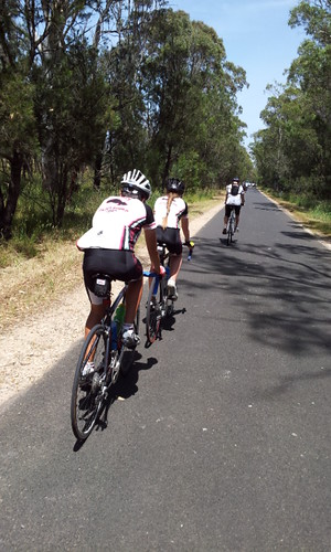
The most obvious changes for me were at the front of the bike. We changed the head stem, changing both length and angle. And I got narrower handlebars, opting for width of 42cm in place of 44cm.

Benefits
There were obvious handling benefits after my bike fit. The front end changes made the bike feel more stable. I was immediately more comfortable that the bike would go where I pointed it. A great example is Trout Farm hill. Strava says its average gradient is 8.4%. Going down there’s a curve right at speed. Before the fit, I would use the whole lane width in that curve, and still feel nervous if there was any hint of moisture on the ground. After the fit I just go with the radius of the road.

I’ve noticed that I can spend more time in the drops. This is especially useful during races where I want to follow along using the least amount of energy. I don’t need to sit up every 1-2km as I would have done previously.

There are benefits also for my feet. In the past I had a few times when, after getting off the bike, the muscles in the soles of my feet were agonising – the only relief was to walk on tip-toe. That hasn’t happened in the year since the bike fit, despite moving to shoes with significantly more stiffness. I sometimes feel muscle twinges in the outside of my right foot, but nothing so painful. And it does not persist off the bike.

Any negative?
One change for the worse is that I regularly get pins and needles in my fingers, sometimes becoming full numbness. It’s not limited to a single hand position when riding: it can happen on the drops, on the tops, or when out of the saddle. I wonder if my newer bars are firmer, or transmit more road buzz to my nerve points? (The change was from carbon to aluminium bars.)

What do I recommend?
The bike fit has been good for me, so I recommend it.

I recommend also that you start better prepared than I did. Especially know how you answer this question, ‘What sort of riding do you want to do?’ I’ve ridden for years, but had only raced for a couple of months before the fit. So I did not know what types of riding I was primarily aiming for (maybe I still don’t!). If you do have a clear answer, it will guide the rest of the fit.

Likewise, before you do any fit, record what you notice on the bike. I had a sense my bars were too wide, so remembered to check this out. I knew about some of my foot pains, so made a effort to pass on as much as I could explain. I deliberately tried to recall what I have liked and disliked about different saddles I have ridden. All this prior info will help the conversation between rider and your ‘Washo’ equivalent.

PS
For those who want to know: Orbea Lobular, 2005 model (second-hand for me); Ultegra 6600; Specialized bars, stem, saddle; Shimano pedals.


Quick review, Albury bike path

I know, my ‘quick review’ posts have all been books so far. And now I want to review a bike path?

There are two positive things, and two negative, about the local bike path connecting Albury with Thurgoona. That sounds like a review to me, so here I go.

Positive: the path

The surface is fantastic. Look at the photo below: good concrete, and very wide. (The extra width was added back when the path was opened, making it very easy to share the path with cyclists, pedestrians, skateboard riders, etc.)

image

Positive: underpasses

Underpasses are great: no need to cross a busy road, and no interruption to walking/running/riding. Most of all, building an underpass shows that the road-builders value non-motorised travel. The photo below shows the Borella Road underpass, looking north.

Negative: double-crossing

For an unknown reason, the good work of avoiding road-crossings was undone in the northern half of the bike path. Why? The example below seems to be for maximum danger – there are two roads to cross, separated by a 10 metre quarter-circle. These two roads are not especially busy, but there is fast through traffic and even some heavy vehicle movement. The worst thing, however, is that these roads come from awkward angles making it hard to scan for danger.

Racecourse Rd, Corrys Rd

Negative: Thurgoona Drive

When the path reaches Thurgoona Drive, pedestrians and cyclists are thrown into the traffic. Thurgoona Drive is a very busy road, and there is no consideration given to keep foot or bike traffic safe. At peak times, morning and evening, someone could be stuck here for ages. Not good, especially since this crossing is close to two schools (Border Christian College, Trinity Anglican School).


Thurgoona Drive ‘crossing’

This last danger spot is hardest to understand. The photo below is only about 50 metres before the crossing shown above: look how the path curves right. It appears possible to go straight ahead and under the rising roadway. All it needed was a corridor like that under Borella Rd.

Embankment straight ahead, a great place for an underpass


Changes to Assen

This is a fascinating blog post. Strictly, it’s a book review. But I am not going to read the original book because I can’t read Dutch!

The book records some of the changes in the town of Assen, in the Netherlands. (That explains the Dutch.) The fascinating thing is considering how a small town has changed gradually but intentionally. The town centre now allows much better pedestrian and cycling transport. It seems that the book is full of pictures, of the THEN and NOW kind. I’ve copied one example below.

1960s v 2007

One thing that surprised me is the size of Assen. In 1955, the population was about 25,000. In 2007 it was 65,000. In other words, this kind of transformation is possible in a town like Albury. With good planning, and time, a better city transport situation can happen.


Disappearing road

This is about some poor road planning, as I see it, that increases danger to cyclists. In two cases, there was a safe riding option that road authorities changed into a dangerous one. In the third case, a careless use of road markings suggests a safe place to ride but increases the risks.

All these examples are in Albury, but I don’t pretend to know who is responsible for each decision and piece of roadwork. For that reason, I am not naming and blaming any local or state authorities. This is a post to point out seemingly thoughtless road set-up.

Atkins St, South Albury

This road is quite new, with a good surface and wide shoulders. Recently there was a change needed – an entry to the parking area for Albury Railway Station. Before the change, there were two lanes going north and one lane south. To make the right turn lane, a third north-going lane was added. The shoulder went from full width to zero.

In the video, you can see former shoulder-lane divider (now painted black), with ‘straight ahead’ arrows painted onto this part of the road surface. The part of the road is already on a curve, so the possibility of being on a bike and hit from behind has increased considerably.

Kaitlers Rd, Springdale Heights

This is a major road in Albury’s north. Running east-west, it receives plenty of traffic. East-west is important, because it means that sun in the eyes is a major problem at certain times. (At the eastern end of Kaitlers Road there are now traffic lights. These lights were put in place after a man was killed at the intersection early one morning. Coming home after night shift he was probably blinded by the morning sun. The media reports included plenty of, ‘We always said the sun makes this intersection dangerous.’)

When some shops were put in on a street corner, the wide shoulder was reduced to zero to create a turning lane for the shopping car park. Would it not have been possible for the car park entry to be on the smaller side street?

As the video starts, you can see the bike symbol painted on the road. I edited out about a kilometer of footage before the present start – the lane has plenty of these painted signs. Just as the lane/shoulder disappears, you can see briefly a signpost on the left: bike lane. What is the point of that? Did someone feel guilty? I am confident it makes no safety difference at all.

To make this decision even worse, the disappearing lane is about 200m from a large high school. The resumption of a normal lane is precisely where the ‘school zone, 40km/h’ starts. Australia says that students should increase their activity levels. And then we act to make riding in the vicinity of school more dangerous. Message and action, in this case, do not agree with each other.

Urana Rd, Lavington

This is a different kind of problem. Urana Rd is a very pleasant tree-lined drive into town. On Atkins St and Kaitlers Rd, the changes were from a good and safe set-up to a dangerous one. I have a lot more sympathy for the difficulty of marking Urana Rd safely. Yet I think it was not done too well.

In the video you will see that the left side of the road has two markings. Broken lines mark parking bays. About a metre away, a solid line apparently indicates the border between cycle lane and motor vehicle lane. Unfortunately, the ‘cycle lane’ is not safe. If anyone were to try and ride it, they would either have to swerve repeatedly into motor traffic, or ride straight ahead into tree roots.

When riding this road, it’s safest to ignore the solid line by riding a metre to the right. This avoids trees, as well as avoiding dangerous and unpredictable swerving. My suggestion for the road markers would be forget the solid line – just include the broken lines.

Thanks to my son Nahum for providing the camera work, keeping us both safe and legal while I did the driving.


Track Cycling world championships

I had the pleasure of watching one night of the Track World Championships in Melbourne (day one of competition, 4 April 2012). There was plenty of great cycling. This video is a sample, for any of my blog readers who wish for a taste.

It’s the final of the women’s team sprint: two laps at full speed, in teams of two, with the first rider pulling out after lap one. The two teams start on opposite sides of the track. I decided I could only follow one team, and went with Australia – world champions for the previous three years. Australia went faster than the world record – and came second! Great effort by Germany (but you’ll have to go elsewhere to see their skills, sorry).